LiDAR of Piedmont Ridge
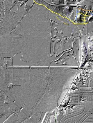
LiDAR of Piedmont Ridge
LiDAR graciously provided by Durant Greenwood.
LiDAR (Light Detection and Ranging) is an active remote sensing technology that uses pulsed lasers to measure distances and create precise, 3D representations of physical environments.
Road and Railroad Orientation
- The thick, sort of curvy horizontal line at the top is Scyene Blvd.
- The thick, long-dashed horizontal line midway is Bruton Rd.
- The thick, short-dashed diagonal line at the bottom left is 2nd Ave.
- The medium, sort of curvy vertical line at far right is N. Jim Miller.
- The thin crescent-shaped line on the right is the DART tracks and the historic railroad that parallels it.
Dallas Water Utilities Pipelines
- orange – in process
- yellow – in planning
- Lacywood, the horizontal yellow line and short vertical above it, are water lines already underway)
- The yellow line and crossbars below it seem to be old and not in use
- dashed yellow – route preferred by FoP
- dark blue – completed DWU sewer line
- Located at the base of Lacywood Overlook, between it and Renda Meadow
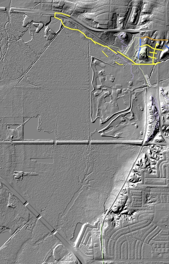
Looking at the above LiDAR from North to South
Scyene Overlook
Small knob below Scyene, west of the words Meadow Loop.
- Roads and Trails:
- The vague vertical line west of Scyene Overlook and north of Scyene is Glover Pass Rd., where the Colonial Baptist Church is located. South of Scyene, it becomes the DART service road that leads to the DART crossing to nowhere.
- The pale white lines are trails.
- Geography:
- The main gully that comes off east Scyene Overlook and goes along the west side of the Renda Meadow Loop. That’s the gully we cross by the huge cottonwood to get to Scyene Overlook.
- Look how it goes under the DART tracks and heads southwest. Super helpful to know about that bend. Many of the oldest/largest trees are found in this water-dispersal/alluvial area.
- Also check out that huge gully coming off the west side of Scyene Overlook. Seems to end in the Beeman black walnut grove at the DART service road and the DART tracks.
Lacywood Overlook
Large knob between the DWU vertical blue line and the DWU horizontal yellow cross bars.
- Lacywood Overlook is larger than realized. A game-changer in terms of additional trails.
Piedmont Ridge Trails
Vertical knob between DART tracks and N Jim Miller north of Bruton.
- Look at the giant ravine between the trails and Jim Miller. Very large and deep! It goes under Bruton and then heads west.
South of Bruton
Deeply folded terrain between the DART track and the residential neighborhood.
- Wow, that’s some rugged stuff. You can see how one deep ravine runs north-south. The Loop Dallas’s trail will go along here, resurrecting a rather famed trail that became closed due to tree falls. What a trail that is going to be!
- The Comanche Storytelling Place is at the southern terminus of the ridge, right above a massive ravine. Holy cow!
Entire Ridge
- Interesting to see how curved it is. Tom Dill, a geologist, said a curve like that must have been formed by water and that perhaps White Rock Creek shaped it that way eons ago.