Proposed Re-route of DWU Water Main at Piedmont Ridge
Proposed Re-route of DWU Water Main at Piedmont Ridge (Lawnview DART Station to Gateway Park)
by Amy Martin, coordinator, Friends of Piedmont Ridge
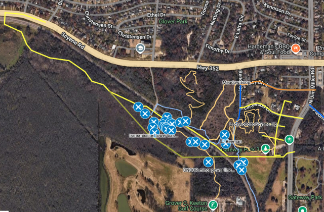
See the proposed path of Dallas Water Utilities (DWU) water main heading south of the Lawnview DART Station.
- orange – in process
- yellow – in planning
- dark blue – completed
The goals with the alternative water main route (details below) are:
1. Save DWU’s effort in removing large trees and money in complying with tree mitigation ordinances, and also the effort in removing abandoned transmission tower bases.
2. Prevent the DART tracks from becoming inundated with standing water during heavy rain.
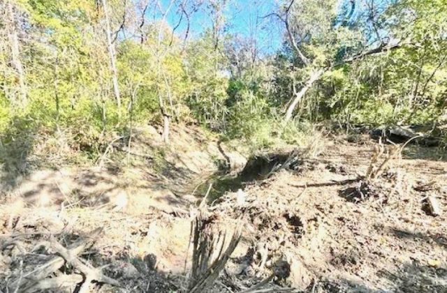
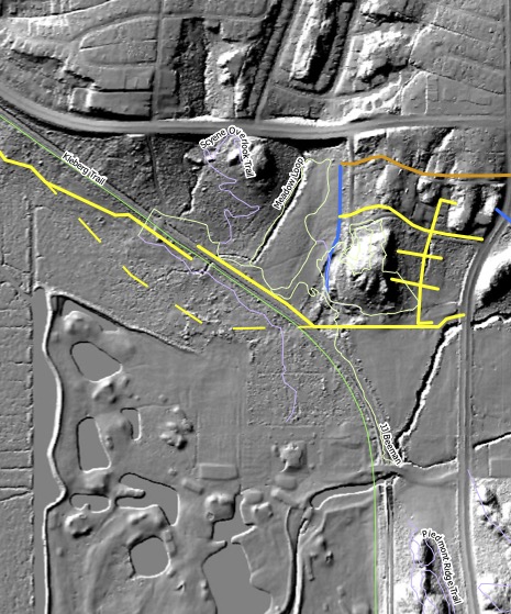
The ridge’s limestone absorbs very little rain, so the culvert beneath the DART tracks carries a LOT of water off the ridge during storms. See the LiDAR below and examine the depth of the gully that feeds it, located along the words Meadow Loop.
The farther the DWU line is from the DART tracks, the more space there is for water to disperse and be absorbed. The congregation of the largest trees roughly matches the alluvial dispersal area.
3. Preserve the Loop’s considerable investment in the White Rock Bluffs Trail by shifting the water main tunnel underneath the DART tracks so that the DWU line goes across the trail and not along it as currently planned.
4. Reduce the impact to the users of Dallas Parks baseball field at 2725 N Jim Miller by shifting the water main path from crossing the infield and parking lot to the outfield.
The historic pecans from the turn-of-the-century pecan plantation west of the DART tracks will have to be taken into account for this rerouting.
4. Friends of Piedmont’s concerns are:
- Prevent the JJ Beeman Trail, currently in the DWU water main path, from being destroyed.
- Save the majestic pecans and cottonwoods in the alluvial dispersal area mentioned above.
- Preserve the series of historic transmission tower bases.
Piedmont Pipelines & Trails Map
A complex map by Durant Greenwood showing:
- Friends of Piedmont (FoP) trails
- The Loop Dallas’s (Loop) White Rock Bluffs trail
- Dallas Water Utilities (DWU) planned water main (close to the DART tracks) and other water and sewer line routes
- Friends of Piedmont’s current proposed alternate route for water main
View the map here
- Center point of area in Google Maps to help with orientation.
- Switch to Satellite layer to see natural features as well.
Map color guide:
- Trails & Features
- pale orange – FoP trails
- light blue – The Loop’s White Rock Bluffs Trail
- sage – water main route most beneficial to the community
- blue Xs – old trees, geographic notes, and historic structures
- DWU Pipelines
- orange – DWU in process
- yellow – DWU in planning
- Lacywood, the horizontal yellow line and short vertical above it, are pipelines already underway
- The yellow line and crossbars below it seem to be old and not in use
- dark blue – completed DWU sewer line
- Located between the base of Lacywood Overlook and Renda Meadow
Ongoing and proposed DWU sewage and water pipeline and water main work in Dallas.
LiDAR of Piedmont North
LiDAR (Light Detection and Ranging) is an active remote sensing technology that uses pulsed lasers to measure distances and create precise, 3D representations of physical environments.
Notes:
- Geography:
- The huge gully comes off east Scyene Overlook and goes along the west side of the Renda Meadow Loop (by the words Meadow Loop). That’s the gully and perennially wet area hikers cross by the huge cottonwood to get to Scyene Overlook.
- Look how it goes under the DART tracks and heads southwest. Many of the oldest/largest trees are found in this water-dispersal/alluvial area.
- Another water factor is the smaller gully coming off the west side of Scyene Overlook. Ends in the historic Beeman black walnut grove at the DART service road and the DART tracks.
- The huge gully comes off east Scyene Overlook and goes along the west side of the Renda Meadow Loop (by the words Meadow Loop). That’s the gully and perennially wet area hikers cross by the huge cottonwood to get to Scyene Overlook.
- Roads and Trails:
- The thick horizontal line at top is Scyene.
- The vague vertical line west of Scyene Overlook and north of Scyene is Glover Pass Rd., where the Colonial Baptist Church is located. South of Scyene, it becomes the DART service road that leads to the DART crossing to nowhere.
- The green line marks the DART tracks. Kleberg Trail refers to a rails-to-trails project much further south.
- The pale white lines are trails.
- DWU Pipelines:
- yellow – DWU in process
- Lacywood, the horizontal yellow line and short vertical above it, are water lines already underway)
- The yellow line and crossbars below it seem to be old and not in use
- dashed yellow – route preferred by FoP
- dark blue – completed DWU sewer line
- Located at the base of Lacywood Overlook, between it and Renda Meadow
- yellow – DWU in process